

What does digitization have to do with the little prince of Antoine de Saint-Exupéry?
 I would like to meet the marketing strategist personally, who has managed to anchor the term “digitization” so comprehensively and at the same time meaningless in our consciousness.
This always reminds me of the episode from the little prince “Draw me a sheep!”. After all attempts to draw a reasonably acceptable sheep have failed, the protagonist of the story paints a simple box and solemnly hands it over to the little prince with the words “In this box is the most wonderful, beautiful and useful sheep you can find can imagine. “.
Et voila, now we come closer to the definition of the term “digitization”. A box full of dreams! Now all you have to do is define what is meant by this in your context.
It’s best to start with the question “Which (entrepreneurial) goal do I want to achieve?”. That would be a good start.
Definitely important in any case are clear definitions of terms and, of course, clear goals: the WHAT, not the HOW.
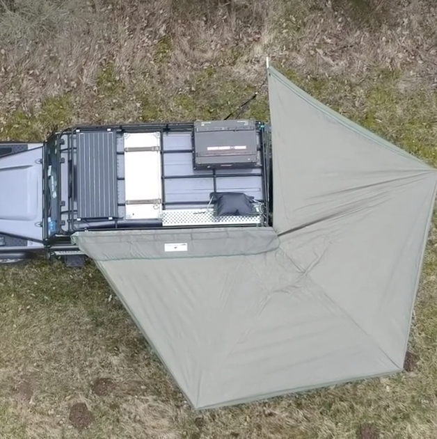
Landrover Defender with awning
Protection from sun and rain and opened within seconds. Ideal for cooling underneath (who wants to cook in the vehicle?).
Bought directly from South Africa and custom made backdated to fit the roof carrier.
Satellite maps on “the go”
The first time I really would have loved to have some satellite imagery available was a while ago when in northern Lappia the track I was following got smaller and smaller and I was worried to get stuck somewhere “in the middle of nowhere” not knowing how this path will continue.
Of course, google earth provides some image cache but this is limited to 2 GB and also has a “timeout” of 30 days.
If there is time to prepare a trip and routes for a specific region, there are varoios software tools around for getting and saving “offline” satellite imagery and display those on a moving map.
A nice tool to create offline raster maps is Mobile Atlas Creator. It has many options, one of them is the possibility to select map tiles along a GPX track.
Per default, it does not have the option to download Google Map Images (this might not be approved by google or legal in your country). To do so, there is another tool / script from Antonis Hapsas which adds this functionality.
This would allow to create image / raster maps, for example in the Rmaps SQLite format which can be displayed by numerous phone and desktop apps.
The workflow for planning an adventure / mission could look like this:
- Overall trip planning with daily drive, breaks, stopovers etc. with Furkot and export as GPX file
- Plan the route with a route planning software, convert tracks in waypoints and expo the GPX file
- Create offline Atlas using MOBAC use the tiles +/- along the route